Avenue of the Giants

Into the Woods

April 23, 2018

The second day of our road trip dawned overcast, and it drizzled off and on as we headed out. I didn’t mind, because I enjoy the novelty of wearing a jacket!

Our first stop was the Humboldt Bay National Wildlife Refuge Complex where we took a blowy, drizzly walk, searching for birds. Most of them were too far away to see well, but we saw red-winged blackbirds both male and female, Canada geese, sandpipers, and a few others I couldn’t identify.


After that, we headed south through the Avenue of the Giants, a 31-mile road running parallel to Highway 101, through Humboldt Redwoods State Park. Humboldt is the largest remaining old-growth redwood forest in the world, and one of California’s largest and oldest state parks. Avenue of the Giants is called one of the finest forest drives in the world—you’ll get no argument from me.


An old-growth or ancient forest has the following characteristics: trees of all ages; may layers of canopy (the uppermost branchy layer); large, standing dead trees, known as snags; large downed logs; large fallen logs in streams; and trees aged over 200 years. The redwoods growing in this area are Coast Redwoods (Sequoia sempervirens)—they’re not the oldest, but they are believed to be the tallest, growing up to 370 feet tall. Coast redwoods only grow naturally in a 40-mile wide by 450-mile long strip from southern Oregon to southern Monterey County in California.
       
The redwood forest is an ideal place to learn about the interconnectedness of life. During a redwood’s lifespan, 1,700 species of plants and animals depend on it. After it dies, 600 species live on a snag, and 4,000 live on or in a downed log.


Redwood sorrel

Redwoods are so large that the base of the tree, the stem, and the crown each lives in a different climactic zone. There are two types of needles, depending on the conditions where they live on the tree.


We took short walks at the Drury Cheney Grove and the Founders Grove. Because of the slightly drizzly weather, we saw few people, and we didn’t hear any birds or other creatures. The woods were hushed and damp and cool.


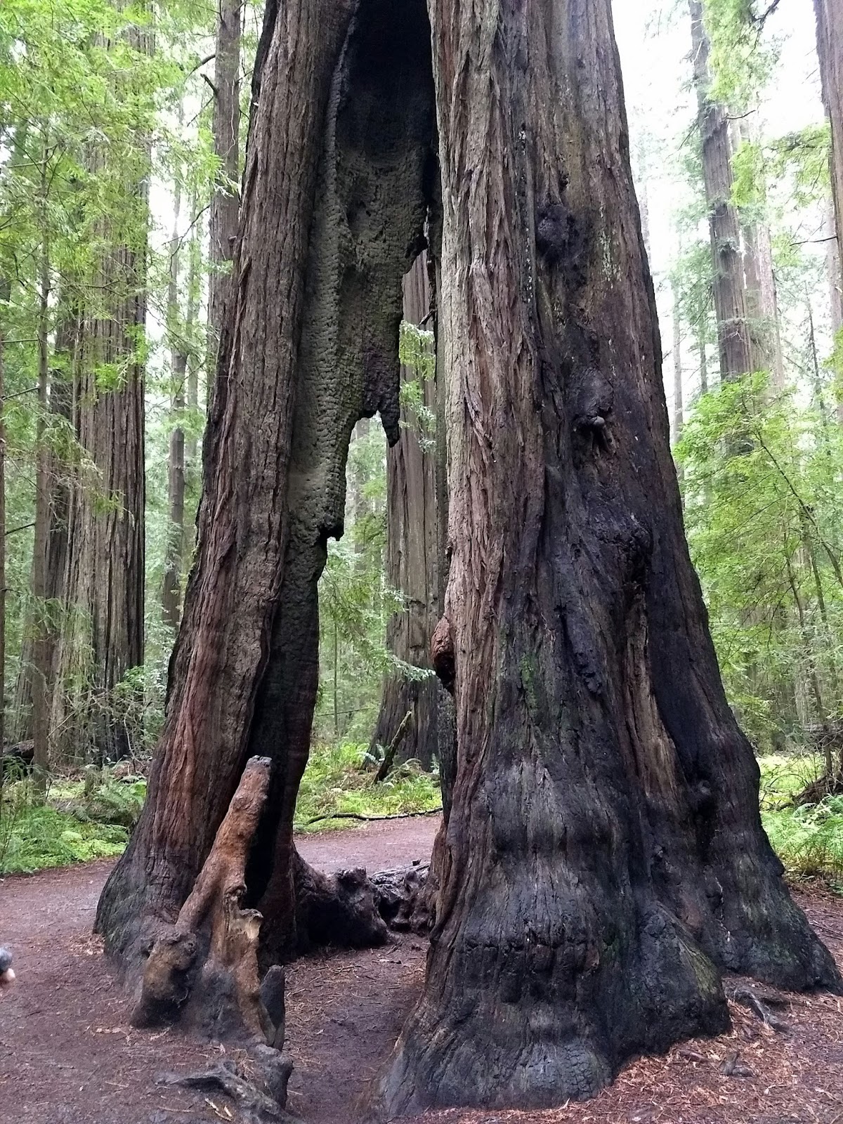
This fire-damaged tree is still living

I learned a cool new word: “windthrow”—the blowing over of trees, and leading cause of redwood death. When the older trees die and blow down, the younger trees have a chance to grow.

This downed tree is known as the Dyerville Giant. Can you see Kerri standing on the right?
In fact, we were forced to detour from the Avenue of the Giants because a tree fell and blocked the road!

We wrapped up the day with a cold and windy sunset on the beach by our hotel in Fort Bragg.

Goodnight sun

Next up: a lighthouse, a light station, and a botanical garden by the sea. Read about the first part of this trip here


California

Birds and Blooms and Winding Roads

April 20, 2018

At least once a year, Catching Happiness turns briefly into a travel blog. Travel makes me happy and I always return refreshed and inspired, though also, in some cases, tired.

For the past three years, I’ve been meeting my teacher friend Kerri during her spring break. We’ve meandered in Florida and the Southwest, and this year was supposed to be my turn to visit her in Seattle. However, my dad has been recovering from a serious bout of flu and bronchitis that put him in the ICU, so I decided that if I went west, I needed to see him. We adjusted our plans so that I could have a quick visit with both my parents before we set out on the road.

Even though I was born and raised in California, with one exception, I don’t recall visiting the areas we traveled through. And certainly not during springtime since previous trips took place mostly during summer breaks or other school and work holidays. All I can say Is, wow, California, you look good in spring.

I couldn’t get enough of the rocky coastline, pounding surf, birds, wildflowers, mysterious winding roads, giant redwoods…but I get ahead of myself. I won’t bore (or torture) you with the entire road trip, but I’ll share highlights of our explorations.

After we left my mom’s, we started our road trip in Redding with a stop at one of my favorite places, the Sundial Bridge and McConnell Botanical Gardens.


One small section of the mosaic fountain area

After that, we drove to Eureka, stopping to take photos at every opportunity. Kerri’s a serious photographer, so while she searched for the perfect shot or set up her tripod, I snapped my own photos or soaked up the difference in climate and geography. Eastern redbuds bloomed all over, a pretty splash of pink in the landscape.


We asked the man at the front desk of the hotel where to watch the sunset, and he said Patrick’s Point:

Good choice.


Sunset at Patrick's Point
Next morning, we had planned to hike to the Punta Gorda Lighthouse, but after a two-hour drive on steep, twisty, and extremely potholed roads, we opted not to take our small rental car through the running water crossing the road.

On the return drive, we dawdled even more than usual, photographing the fog, the flowers, the rolling hillsides, the zebras (why?), and anything else that captured our fancy. We explored tide pools on the beach, collected a pocketful of shells and rocks, photographed a friendly-looking seal. Good thing we missed our hike, because part of the sole of one of my hiking boots came off while we were on the beach.


Zebras!


Hello, there


An interesting road sign:

Say what, now?!
I’m still sorting through the more-than-700 photos I took, as well as sorting through the experiences, interesting facts, and memories we made. Next week, we’ll visit the Avenue of the Giants, the Medocino Coast Botanical Gardens and more. I hope you’ll come back to explore with me!


Arizona

Pictures of Rocks--the Meander Continues

May 01, 2017


Third and final installment of road trip adventures (see part one here, and part two here).

In addition to the striking scenery, good food, and precious hours spent with a friend, one of the best things about my recent trip was the complete break in routine. Routines can become ruts, where life sort of runs on automatic pilot and I don’t think about what I’m doing. After coming home, I have the choice of picking up my previous routines… or not. That’s one of the things I’m still figuring out, two weeks into my return. I feel like I need to change up how I operate.

But I digress.

Before I continue with the travelogue, I have to share with you the Best. Breakfast. Ever.  We ate at Crema in Cottonwood, Arizona both mornings we were in town. If you’re in the area, do not miss it. (No affiliation.)

Crepes with fresh berries and marscapone cheese

Egg sandwich with arugula and sriracha aioli


After fueling up at Crema, we waddled to our car where we took off for further exploration, including: 

The cliff dwellings at Montezuma Castle were home to the Southern Sinagua, and were occupied until the 1400s. Montezuma Castle is one of the best-preserved historic structures of the Southwest. It rises 100 feet above the valley, and consists of five stories and 20 rooms. Early American settlers assumed it was Aztec in origin, so they named it after Montezuma. We walked an easy paved loop trail past the cliff dwellings, down to the river, and back to the visitor’s center.


After the Castle, we stopped by Montezuma Well right at the end of the day, and what a lovely spot it turned out to be! The Well is fed by springs, and more than 1.5 million gallons of water flow into it every day.  The water eventually flows into an irrigation ditch, which has sections that date back over 1,000 years. The Southern Sinagua used water from this well to irrigate crops, and the residents of Rimrock, Arizona currently use it for gardens and livestock. There’s a pretty stiff climb up a hill that leads you to this:


We also climbed down to the water level of the well, and followed a trail along where the water flows out of it. 

In a previous post, I promised striking rock formations, and here they are:


Bell Rock and Courthouse Butte, near Sedona, Arizona. We stopped here briefly before sunset, dinner, and heading back to our hotel for the night.

The last place I’ll take you on this road trip is also one of my favorites: Horseshoe Bend. Horseshoe Bend is near the Grand Canyon, but not technically part of it. You can take an aerial or land tour, but you can also park and walk to the rim for free. Once there, look down 1,000 feet to the Colorado River as it winds around a 270-degree, horseshoe-shaped bend. This is known as an entrenched meander. Isn’t that a wonderful name?


We visited Horseshoe Bend twice, hoping for some good sunset photos, but it was too hazy each time. That didn’t matter—with or without sunset, Horseshoe Bend is photogenic, and the people watching was also entertaining. Stressed-out parents trying to keep their kids safe but still allow them to see and photograph the scene, couples cautiously creeping to the edge of the canyon to take selfies (or foolhardily marching up to the edge), Kerri trying for the perfect shot without losing her camera and tripod into the abyss. Once I snapped my photos, I sat and soaked up the scene while she experimented with settings and tripod placement, letting my eyes wander over the landscape, feeling the slight breeze on my face.

Scenery around Horseshoe Bend

Yes, we were this close to the edge
I hope you’ve enjoyed our little jaunt into Arizona and New Mexico. It’s not always a pleasure to hear about someone else’s adventures when what you really want is to have your own! (Fair warning: there will probably be at least one future Field Trip Friday post based in the Southwest!)

What is your next adventure?

Everyday adventures

From Petroglyphs to Ice Caves—the Enchanted Meander* Begins

April 24, 2017


Installment two of the great Arizona/New Mexico Road Trip...

Let me tell you a little secret about traveling with my friend Kerri. You’d better be ready to GO. She packs more into a day than almost anyone I know. I’m grateful for this, because I’m a bit of a slug by nature. Each day of our trip was chock full of seeing the sights, driving, talking, eating, listening to music or podcasts, hunting that perfect photo, and exploring anything that caught our interest. Last week, I skipped ahead in our trip to write about Antelope Canyon, but now I’m backtracking to our first day’s adventures: 

Petroglyph National Monument is just outside Albuquerque, New Mexico, and it was our first stop on the trip. After checking in at the visitor’s center for advice on where to go if we didn’t have much time, we settled on Boca Negra Canyon. It was a beautiful morning, with cobalt blue skies and cool temperatures. A few minutes easy walk brought us into an area of tumbled volcanic rock, and the petroglyphs were easily spotted on the dark surfaces. These markings were created by Native Americans and early Spanish settlers approximately 400-700 years ago. This area is considered a sacred landscape by the American Indians, according to the Park Service brochure.


We also caught glimpses of the wildlife of the area—rabbits, quail, lizards, and what might have been ground squirrels or prairie dogs—they were too fast and too far away to tell.


 Our next stop was a roadside attraction we stumbled upon:


Located in a collapsed lava tube, the ice on the floor is approximately 20 feet deep. The deepest ice dates back to 1100 AD. Arctic algae causes the ice’s green tint.


We finished off the day sunset gazing on the way to Cottonwood, Arizona:


Where we stayed at the delightful Iron Horse Inn.


In our next installment, our intrepid travelers discover perhaps the world’s most delicious breakfasts, cliff dwellings, and even more stunning rock formations.

*Kerri dubbed her Facebook photo album for our trip “An Enchanted Meander”—and I’m shamelessly appropriating the name.

Adventure

Where the Wind Lives

April 19, 2017


This is installment one of my 2017 Arizona/New Mexico road trip adventures with my friend Kerri. 

As we bumped down the dirt road to the mouth of the canyon, tour company owner Jackie told us that Navajo culture is matriarchal, and the land we were seeing belonged to her mother. The rocky landscape was her home, the place she felt most comfortable. Just before she dropped us off, her words captured my imagination: “This is where the wind lives.”

Antelope Canyon, near Page, Arizona, is one of the most visited slot canyons in the Southwest. (Slot canyons are narrow, deep canyons carved by water.) Tours go to Upper and Lower Antelope Canyon, as well as a few lesser-known canyons. We chose to visit “Canyon X,” with Taadidiin Tours (no affiliation).

After Jackie dropped us off, we descended into the canyon itself, where we were met by a guide. The sandstone curves, swirls, and corkscrews, carved by wind and water into sinuous shapes. Colors range from pale peach to deep purple, depending on the angle of the sun. 


When the sun shines into the canyon just right, you can see the elusive trademark Antelope Canyon shaft of light. As we walked deeper between the curving walls, we saw our first one. (The guides toss fine sand into the air so it shows up in photos.)


If ever there is a place to look up, look down, look all around, it is here.

Looking up
The guides helped us with our camera settings so we would get the best shots, and though they kept an eye on us, they allowed us to freely explore. It wasn’t mobbed with people the way the Upper and Lower Antelope Canyon tours can be, and we were able to take our time exploring, taking photos, and soaking up the peaceful atmosphere. I was even able to sit quietly and make a quick sketch of a section of the canyon. (The challenge will be mixing watercolor representative of the shades of rock I saw!) 

A few more photos: 

Canyon resident

Looking down into the canyon entrance from where we were dropped off.


Canyon X was a magical place, and a not-so-everyday adventure. I highly recommend a visit, and Taadidiin Tours. (See their website, above, or check out their Facebook page here.)